文章信息
Zhang, J., Fukuda, T., & Yabuki, N. (2021). Development of a City-Scale Approach for Façade Color Measurement with Building Functional Classification Using Deep Learning and Street View Images. ISPRS International Journal of Geo-Information, 10(8), 551.
论文摘要
城市立面色彩的精确测量是城市色彩规划的重要内容。现有的人工测量建筑立面颜色的方法受时间和人力成本的限制,很难在城市规模上进行。这些方法也使得确定建筑功能在控制和指导城市色彩规划中的作用变得具有挑战性。本文利用最先进的深度学习技术和街景图像,探索了一种城市规模的立面颜色测量方法,其中包括建筑功能分类。首先采用语义分割的方法提取建筑幕墙,并对采集到的街景图像进行色彩校正,对采集到的街景图像进行预处理。然后,提出了一种基于颜色表的立面颜色度量方法和一种基于多标签深度学习的建筑物分类方法。其次,以实地调查数据为基础,验证了立面色彩测量和建筑功能分类的准确性。接着,将该方法应用于中国三个大都市的建筑立面色彩分布图生成,结果证明了该方案的可移植性和有效性。拟议的方法可以为城市管理者提供城市规模区域内城市立面颜色和建筑功能的整体感知,有助于为城市分析和规划提供数据驱动的决策。
Abstract
Precise measuring of urban façade color is necessary for urban color planning. The existing manual methods of measuring building façade color are limited by time and labor costs and hardly carried out on a city scale. These methods also make it challenging to identify the role of the building function in controlling and guiding urban color planning. This paper explores a city-scale approach to façade color measurement with building functional classification using state-of-the-art deep learning techniques and street view images. Firstly, we used semantic segmentation to extract building façades and conducted the color calibration of the photos for pre-processing the collected street view images. Then, we proposed a color chart-based façade color measurement method and a multi-label deep learning-based building classification method. Next, the field survey data were used as the ground truth to verify the accuracy of the façade color measurement and building function classification. Finally, we applied our approach to generate façade color distribution maps with the building classification for three metropolises in China, and the results proved the transferability and effectiveness of the scheme. The proposed approach can provide city managers with an overall perception of urban façade color and building function across city-scale areas in a cost-efficient way, contributing to data-driven decision making for urban analytics and planning.
文章下载链接
https://www.mdpi.com/2220-9964/10/8/551
研究框架

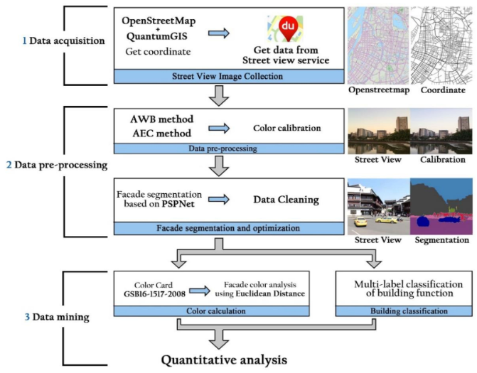
为了开发一个在城市尺度上自动计算和识别城市立面色彩和功能的系统,我们首先收集了大量的街景图片作为数据支持。然后,将颜色校正和数据清洗方法应用于街道级图像。接着,我们提出了一个基于颜色表的立面颜色测量方法和一个用于建筑物分类的多标签深度学习网络。